
Margurite Spicer Bulkley, life-long resident of Fountain and Pueblo, recorded the stories she grew up with. These stories are included in Bulkley’s four-volume set of scrapbooks housed at the Pioneer Museum in Colorado Springs, a transcription of which is archived in the Carnegie Library in the same city. These are stories about life in the Fountain Valley. For information on the historic families see: http://sites.google.com/site/lifeandlegendofthelocks/
---------------------------------------------------
Margurite Spicer Bulkley’s story of . . . The Murder of Henry Hawkins
[In all other accounts, Henry’s name is spelled Harkins. Other sources spell the name of the Mexican bandits as Espinosa.]
In the year of 1863, Louis Priest and his young family moved from Buckskin Joe, near Cañon City, and homesteaded along the Little Fountain Creek. Henry Hawkins, who lived nearby, soon became good friends with his new neighbors. On March 16, while Louis and his son, also named Henry, were out hunting, they found the body of Henry Hawkins. He had been shot and his head was split open. They buried him in the canyon where they found him and then took up the trail of the murderers, but never caught up to them. It was supposed that the killers laid in wait on the high rocks above the canyon where it was narrow and shot Henry Hawkins from there. This place became known as Dead Man’s Canyon, and over the years stories were told of ghost riders up and down the canyon.
It didn’t take long before the crime was blamed on the Mexican Espinoza Brothers. These religious fanatics had a vision in which they were told to kill all the Anglos they could find. Their first victim was William Bruce who ran a saw mill on Hardscrabble Creek; the second victim was Mr. Hawkins. A man named Addleman was the third man killed, and he was found on a road near Cañon City. Other victims included two merchants and a soldier in Conejos. The number killed amounted to 35 before the brothers were stopped. A book was found in which they kept a record of their murders.
Felipe, the larger of the two brothers, kidnapped two sisters. He forced the older one to live with him. He was very cruel to her and would be gone for months. Every time he left, he gave her stolen jewelry and money. The younger sister later became Mrs. Lucero.
Eventually, Jonathan McCannon led a posse of volunteers that tracked the Espinoza brothers to their hideout. Felipe was shot but his brother got away and made it back to his people where he persuaded his nephew to join him in continuing the killing spree.
By this time, there was a reward out for the Espinozas. Tom Tobin, an Indian trader, crawled up to their camp one night and shot both of them. He cut off their heads and took them in to collect the reward. Some say the state never paid him for his trouble, but others say he took the heads to Fort Massachusetts and collected his reward there.
Henry Priest lived his life as a bachelor on the Priest homestead until his later years when he had to go to the Poor Farm. His last request to be buried next to Henry Hawkins was granted, and he was laid to rest in Dead Man’s Canyon. The two bodies were later moved to a spot across the road and a marker was placed at the site.
Editor’s note: According to the 1870 Colorado census for El Paso County, Lewis Priest lived in the area served by the Fountain post office with his wife and children. Twenty-one-year-old Henry Priest was living with the Hall family as a farm laborer. They lived within the El Paso post office area. Does anyone know where this was? Editor cannot find Henry Priest on any Colorado census index after 1870. There was a John McCannon who lived in Lake County.
[By broadening the search, we find Henry Priest, born Indiana or Iowa in about 1850, working as a tie cutter in Silver Cliff in 1880, and as a resident of the Penitentiary in Canon City in 1900. El Paso Post Office was located south of the Buttes, along the Fountain Creek. Henry Priest was living with Benjamin Hall, an early settler and land speculator. Lucretia Hall, his wife, made cash entries on several ponds and springs on the mesa west of their house, on what became Fort Carson.]
The following articles provide more interesting information regarding Bulkley’s story of the Espinoza Brothers.
Little Fountain Creek – Dead Man’s Canyon at http://www.georgia-ghost-hunters.com/modules.php?name=News&file=article&sid=65
Henry Harkins – Dead Man’s Canyon at http://www.waymarking.com/waymarks/WM8HXC_Henry_Harkins_Dead_Mans_Canyon_El_Paso_County_CO
The Bloody Espinosas at http://www.legendsofamerica.com/outlaw-espinosagang.html
Severed Heads Haunt the Capitol at http://mcoulterfineart.com/hide/hysterical_history/espinoza_brothers.htm
Pioneer Tobin Led Life of Adventure at http://www.santafenewmexican.com/Local%20News/Pionner-Tobin-led-life-of-adventure

The Bulkley files also contain maps of town, with notes on who may have lived where in what year, based on her memory of stories.
The South Main Street map includes:
- Henry Hutchin store 1863
- Ice house
- Terrell 1859 house, freight/stage stop
- Mann Pond and 1906? house

The Main Street/ school map shows:
- L shaped school split into feed store and opera house
- Link Hotel 1885
- Shops on Main Street
- Lock Ames store
[Note the Kinder boarding house, thought to be the house at 232 S Main that stood the blast, as built in 1898. North of it is the First School Park, now the library. The town campground would have been nearby.]

 |
| Town Campground |

 |
| Walnut east of Main |

- Baptist, Catholic, Congregational and Free Methodist churches
- Spicer's Cafe
- Hayfields and orchards
- Orcutt's station and McBride's blacksmith

The map of North El Paso shows:
- Perkins 1869 at El Paso and Terril
- Rev. Boss on Wellington
- Hotel O'Riley by D&RG depot
 |
| 104 Wellington, originally owned by W. Riddock in about 1898 |
 |
| Perkins house at El Paso and Alabama |
 |
| Hanover by the D&RG depot, Hotel O'Riley? |
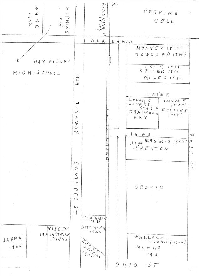
Map of North Santa Fe shows:
- Lock House on Race 1881
- later the Spicer House 1885
- 1934 Highway
- Virden at Santa Fe and Ohio
- Bitties Station 1935
Reverend William Loomis, born 1872, built a house on the corner of his parents lot, on the northwest corner of Ohio and Race. He married in 1905 and moved to Kansas in about 1915, which is where he was probably ordained.]

Map of Santa Fe Highway from Ohio to Illinois shows:
- Hotel Mitchell 1872
- Peebles diner
 |
| Wm Christian, west Missouri |

Map of South Santa Fe shows:
- Irene Benedict's home
- Santa Fe Depot
- Baptist Church's original location
- Cemetery
----------------------------------------------------------
Ghosts of Dead Man's Canyon

This story is about the area between Canon City and Colorado City, probably pretty close to the Highway 115 route. Folks from early Fountain considered the inhabitants west of Fountain their neighbors and were interested in any news from the area.
Early in June of 1867, reports of ghost sightings came from freighters on the road between Canon City and Colorado City. The men recounted that they saw apparitions of a horse and a dog. Apparently, the freighters’ horses saw this, too, as they would become frightened and run away. At this time, a new road was under construction and as soon as it was completed, the old road was closed off to traffic.
Early in June of 1867, reports of ghost sightings came from freighters on the road between Canon City and Colorado City. The men recounted that they saw apparitions of a horse and a dog. Apparently, the freighters’ horses saw this, too, as they would become frightened and run away. At this time, a new road was under construction and as soon as it was completed, the old road was closed off to traffic.
In September, a freighter by the name of Capt. M. P. Felch was on a trip from Denver to Leadville. While he was stopped at Canon City , he received a letter from his wife asking him to return home immediately. Leaving his wagon behind, he took a horse back to Denver and chose the old road since it took less time to travel.
In the letter, Felch’s wife told him some disturbing news about one of his old friends, Oliver Kimball. Felch and Kimball were both from Vermont and had served in the Civil War together. After the war, Kimball acquired a mining partner named Dave Griffin and together they worked a claim at California Gulch, located just south of Leadville. Meanwhile, Felch went into the freighting business. Felch’s wife informed him that Kimball had sent for his sweetheart to join him in Denver . When she arrived Kimball did not show up to meet her. She then had a dream that recurred three times in which she saw her loved one dead in a deep red canyon with a knife in his back. She noticed the terrain around him included cedar trees and rabbit brush.
It was dusk as Felch entered the red canyon. His horse suddenly shied and both of them saw the ghosts of a horse and a dog traveling in the direction of Canon City . Felch watched as the ghost horse reached a rock jutting out into the road. The horse and dog appeared to become frightened of something and then both disappeared. As Felch continued on his way, he came upon the horse and dog again, showing interest in the rocks and brush in the road. Felch’s own horse became scared and bolted his rider out of the canyon.
A few days later, Felch returned to the canyon with the sheriff and dug at the place where the ghost horse and dog were digging. They unearthed the body of Oliver Kimball with a knife in his back. The initials D. G. were carved into the handle of the knife.
Felch took the knife and made a trip to Leadville to pay a visit to Dave Griffin. He asked about Oliver Kimball. Griffin reported that after making five thousand dollars Kimball took his horse and dog and left for Vermont to get married. Griffin tried to talk him out of getting married and followed him to Canon City. When Felch showed Griffin the knife, he went into the next room and shot himself. There were no more sightings of the ghost horse and dog.
[Marshall P. and Amanda Fetch appear on the 1870 census living in Montezuma, Colorado. Marshall was born in Massachusetts in about 1834, but was living in West Fairlee, Vermont in 1860, working as a shoemaker.
Oliver Kimball and Dave Griffin could not be identified on the census, and do not appear among historic Colorado newspapers indexed online.]
-------------------------------------------------------------------------
Travelers heading to Colorado City from Pueblo took the [Cherokee Trail]. From Pueblo, the wagon road followed the Fontaine Que Bouille, now known as Fountain Creek. At Buttes, named for the distinguishing teepee shaped hills nearby, the traveler could rest and restock at the Lincoln Trading Post. Mr. Lincoln had resided in the area for quite some time prior to Tom’s arrival and had fortified the post to serve as a protection against Indian attacks. However, because of his fair dealings with the Indians, he was never harmed by them.
Submitted by Angela Thaden Hahn
Oliver Kimball and Dave Griffin could not be identified on the census, and do not appear among historic Colorado newspapers indexed online.]
-------------------------------------------------------------------------
The Cherokee Trail
When writing about early Fountain settler Tom Owen, Bulkley prefaced her story with some background information on what she called the Santa Fe Trail . It is believed she was referring to the Cherokee Trail, a spur that turns north from the Santa Fe and heads all the way to Cheyenne. The following is her description.
Travelers heading to Colorado City from Pueblo took the [Cherokee Trail]. From Pueblo, the wagon road followed the Fontaine Que Bouille, now known as Fountain Creek. At Buttes, named for the distinguishing teepee shaped hills nearby, the traveler could rest and restock at the Lincoln Trading Post. Mr. Lincoln had resided in the area for quite some time prior to Tom’s arrival and had fortified the post to serve as a protection against Indian attacks. However, because of his fair dealings with the Indians, he was never harmed by them.
At Buttes the trail split; freighters and covered wagons forded the river to the east side where it continued on to points north. The stage continued on the west side of, and eventually away from, the river and toward the foothills. This branch off of the main trail was probably known by another name.
The east side of the road, the Cherokee Trail, followed the river to Kelker [now marked by a railroad sign between E. Las Vegas Street and Hancock Expressway in present-day Colorado Springs
After leaving Buttes, travelers on the stage road followed the Little Fountain. At the point of crossing this creek was a stage stop known as the Charter Oak. [It is believed this location is now part of Fort Carson.] The house there, made of grout, was surrounded, along with the corrals, by a protective wall. Conveniently located nearby was a natural hay meadow used to feed the extra horses that served as replacements for the stage coach.
The road continued on along the foothills until it reached Colorado City. This part of the trail was considered among the Indian tribes to be neutral hunting ground. Travelers along this stretch of the road were not concerned at the sight of Indians as they knew the natives were hunting game and not scalps.
In one of the caravans heading north along the [Cherokee Trail] in 1858, “. . . a young man by the name of Thomas Owen walked alongside a wagon. He had paid fifty dollars for the privilege of putting his few belongings in the wagon.” The caravan forded the river at Buttes and Tom passed by the site that would be his future home. [He no doubt noticed the fertile and well-watered ground.] Tom went on to Denver and in the fall he returned to the east. Just a year later he was back out west.
Submitted by Angela Thaden Hahn
 |
| From glorecords.blm.gov Survey maps |
A Closer Look at the Cherokee Trail in the Buttes Vicinity
It should be considered that many of the stories included in Bulkley’s scrapbooks took place long before she was born and therefore were told to her by others. By the time she heard them, some of the truth to them may have been altered a little . . . or a lot. After all, stories are changed every time they are told. The stories as she understood them are worth recording anyway. Even though they may contain some blatant errors, they may also help to polish the history of the Fountain area. After checking out various elements of Bulkley’s [Cherokee Trail] story, here is what was discovered.
A study of maps—a combination of Google Earth’s Earth Point Townships, original plat surveys at the Bureau of Land Management General Land Office Records, and MapQuest’s current mappings—shows some interesting things when considering Bulkley’s story of the [Cherokee Trail].
She mentions the Lincoln Trading Post in the Buttes area. The 1864 plat survey of township 16S range 65W does not label the trading post area with anyone’s name, though it seems to be agreed by Fountain historians that Lincoln certainly did live there in the 1860s.
This same survey shows that the Colorado and Pueblo Road, which was probably the former Cherokee Trail, went along the east side the Fontaine qui Bouille rather than the west side as Bulkley’s story goes. Bulkley says it was just six years prior to this survey when Tom Owen made his trip past the area.
Any fording required to branch off in another direction would have been to cross the Fontaine from the east side, but no fords are noted on the 1864 survey.
Bulkley says Tom followed the Little Fountain in a northeasterly direction toward Colorado City on a stage road. The 1864 map shows no trail along Little Fontaine qui Bouille, but one is clearly marked on the north side of the creek on the 1870 plat survey of township 16S range 66 west. Roads naturally followed water ways and perhaps travelers were using this creek as a roadway even before it was marked.
Bulkley says that the road following the Little Fountain eventually crossed the creek at a place known as the Charter Oak. The 1870 map shows no crossings over the Little Fountain; however, it was necessary to cross Rock Creek near it’s junction with the Little Fountain. It is not known that this was in fact a stage route, but travelers may have stopped at this place she named Charter Oak. Or it may be she is describing the Little Fountain road as it was later when Tom returned to the Fountain Valley.
Interestingly, a Colorado Springs Gazette article from 1886 says the Charter Oak Ranch was not always known by that name. Prior to its name change in 1886, it was known simply as the Jack Brown Ranch. Perhaps the story teller used the ranch’s current name when telling the story to Bulkley years after 1858. The 1870 map shows a couple of homes along Little Fontaine qui Bouille, but none are owned by Brown.
Finally, the trail along Little Fontaine eventually meets the road that leads to Colorado City so this could have indeed been a chosen route to that town.
______________________________________
History of the Fountain Post Office, compiled by Mrs. Peggy Bulkley
with notes from other sources [editor]
Appointments
1864 Amos Terrell appointed postmaster, had it in his house
1871 Edward H Gould
Feb 12 1873 Clayton Craft
Apr 27 1880 Henry Hutchins
Jul 20 1883 Elvina Hutchins appointed postmistress
Feb 5 1886 Albert J Benedict
[1888 TJ Benedict listed in Fountain Herald]
1897 Grace Hutchins appointed.
Post office was in Hutchins Store [313 S Main] until 1912, when Grace built a house on Missouri [actually most people think it was this house on west Ohio] and had it there. In 1914 it was moved to the back of the Gore Store [Woodmen Hall]. When Albert Benedict had it he was in the back of the store that Mr. Crabb ran, and he had it in the Terrel place later it is thought.

 |
Colorado City Iris 1904 |
This newspaper article suggests that the Postmaster in 1903 was __________ Bell.
[Mrs. Bulkley's notes continue.....]
Sep 18 1914 Loren Gore
Dec 10 1919 Nellie Pyles
1924 Cora Northup
1926 Post Office moved to store north of FE Torbit's store
1928 Cora Northup reappointed
Dec 2 1936 Nellie King
------------------------------------------------------------------
In 1986, the El Paso County DA's office received evidence - that of the confession of John Spicer to the murder of John Sebastian. Agent Mooney conducted an investigation and interviewed Marguerite Spicer Bulkley. Case #1986DA029 can be viewed at the PPLD Special Collections in the volumes Homicides of El Paso County.
The following are details from his study:
John Spicer came west from Michigan in about 1885, and worked for Mr. Loomis in the livery stable. After stints on a cattle drive, and doing carpentry work with his brother Alonzo in Denver, he came back to Fountain. He married Hovena Lock in Fountain and moved into a house her mother Barbara gave them in town. On May 14, 1888, the train collision at the Fountain depot did not awaken them, but the explosion sent a door sailing into their bedroom, just missing the baby. The south wall of the house was blown out. Over the winter of 1888 they moved in with her brothers at the Lock ranch. In 1893, the Spicers were living on the Ames place north of the Lock Ranch, while he built a new house south of the Locks. John worked for the railroad on and off from 1904 until 1907. In 1908, he went on a drunk and tried to kill his son. Hovena told him to leave, and he went back to the railroad work.
When asked, Marguerite said that she had heard of a Sebastian family who lived in Fountain at one time, but did not know them. She said that her father was a violent drunk, and that during the summer the children would sleep out in the fields at night because they were afraid of him. Marguerite said that the house the molding came from was Mr. Loomis' house, one of the first two-story homes in town.
Later Mrs. Bulkley contacted the detective to give another side to the story. She said that her father had purchased land east of Fountain on Sand Creek [the local name for Jimmy Camp Creek at the time]. He was working on a fence when a man tried to jump him, so he hit him in the head with a post. The man died, but John reported this to the local marshal. There was no ID on the man, and the matter was let drop. Mrs. Bulkley said that the murder happened before she was born, but that she had heard about it from her sisters and mother. But her father would not have murdered a man for his money.